
Vicarious Calibration - Cal/Val Wiki
Vicarious calibration refers to techniques that make use of natural or artificial sites on the surface of the Earth for the post-launch calibration of sensors. These targets are imaged in near-coincident fashion by the sensor to be calibrated and by one or more well-calibrated sensors from satellite or aircraft platforms or on the ground. [1]
___________________________________
Over the last 10-20 years vicarious calibration has become widely adopted as the means to provide independent assurance of the quality of remotely sensed data from spaceborne sensors. Much of the credit for this must go to researchers in the Remote Sensing Group in the College of Optical Sciences at the University of Arizona , who have devised and published various methodologies for vicarious calibration. (Thome, 2004)
High altitude dry lake beds are widely used as vicarious calibration targets, for example White Sands Missile Range, New Mexico, Railroad Valley, Nevada, and Lunar Lake, Nevada in the US (Thome et al., 1998), Salar de Uyuni in Bolivia, Salar de Arizaro and Barreal Blanco in Argentina, Tuz Gölü in Turkey, and Lake Eyre in Australia.
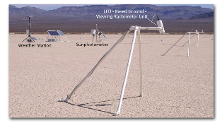
As an alternative to natural targets for this purpose, artificial targets can be installed, such as calibrated tarpaulin sheets. A practical limitation of this approach is the size of the sheets needed, which should be at least 5 x 5 pixels in size to allow for uncertainty in geometric correction and the point spread function of the detector. [2]
_____________________________
References
[1] Canada Centre for Remote Sensing - CCRS - http://www.ccrs.nrcan.gc.ca/optic/calval/primer_e.php
[2] NCAVEO - http://www.ncaveo.ac.uk/calibration/radiometry/in-flight/
Literature
Thome, K. J., 2004. In-flight intersensor radiometric calibration using vicarious approaches. Post-launch calibration of satellite sensors. Morain, S. A. and Budge, A. M. London, Taylor and Francis, 95-102.
Thome, K. J., Schiller, S., Conel, J. E., Arai, K. and Tsuchida, S., 1998. Results of the 1996 Earth Observing System vicarious calibration joint campaign at Lunar Lake Playa, Nevada (USA). Metrologia 35, 631-638.
Thome, K., Gellman, D., Parada, R., Biggar, S., Slater, P. and Moran, M., 1993. In-flight radiometric calibration of Landsat-5 Thematic Mapper from 1984 to present. Proceedings of the Society of Photo-Optical Instrumentation Engineers (SPIE), SPIE, 47-59.
Bannari, A., Omari, K., Teillet, P. M. and Fedosejes, G., 2004. Multi-sensor and multi-scale survey and characterization for radiometric spatial uniformity and temporal stability of Railroad Valley Playa (Nevada) test site used for optical sensor calibration. Proceedings of SPIE - The International Society for Optical Engineering 5234, 590-604.
Abdou, W. A., Helmlinger, M. C., Conel, J. E., Bruegge, C. J., Pilorz, S. H., Martonchik, J. V. and Gaitley, B. J., 2000. Ground measurements of surface BRF and HDRF using PARABOLA III. Journal of Geophysical Research 106, 11,967-11,976.
Rondeaux, G., Steven, M. D., Clark, J. A. and Mackay, G., 1998. La Crau: A European test site for remote sensing validation. International Journal of Remote Sensing 19, 2775-2788.
Wu, D., Yin, Y., Wang, Z., Gu, X., Verbrugghe, M. and Guyot, G., 1997. Radiometric characterisation of Dunhuang satellite calibration test site (China). Physical measurements and signatures in remote sensing. Guyot, G. and Phulpin, T. Rotterdam, Balkema. Volume 1, 151-160.
Six, D., Fily, M., Alvain, S., Henry, P. and Benoist, J.-P., 2004. Surface characterisation of the Dome Concordia area (Antarctica) as a potential satellite calibration site, using Spot 4/Vegetation instrument. Remote Sensing of Environment 89, 83-94.
Child Pages (1)
-
Reflectance Based Method
The Reflectance Based Method is based on the simultaneous measurement, during the satellite sensor overpass, of a well known target (e.g. Salt Lakes or very bright surfaces) with a well...