
Sampling
- headline
- text
-
SALVAL HOME
Using the Tool
Sampling
Contact & Acknowledge
The validation and intercomparison exercise are performed over two different ensembles of sites:
- REALS (Representativeness-Evaluated ALbedo Stations): These are a collection of 99 sites where the direct point-to-pixel comparison was assessed, which involves direct comparison of medium resolution satellite product pixels with albedo measured from in situ tower-based instruments. The spatial representativeness of the in situ albedometer footprint was evaluated for the satellite pixel according to CEOS LPV good practices adopted for validation ( Román et al., 2009, 2010).
- LANDVAL (Land validation): These sites are a sampling of 720 homogeneous sites used for a satellite product-to-product validation approach, referred to as satellite product intercomparison. LANDVAL was designed to globally represent the variability of land surface types (Fuster et al., 2020; Sánchez-Zapero et al., 2020). LANDVAL includes CNES desert calibration sites (Lachérade et al., 2013) for precision and stability evaluation.
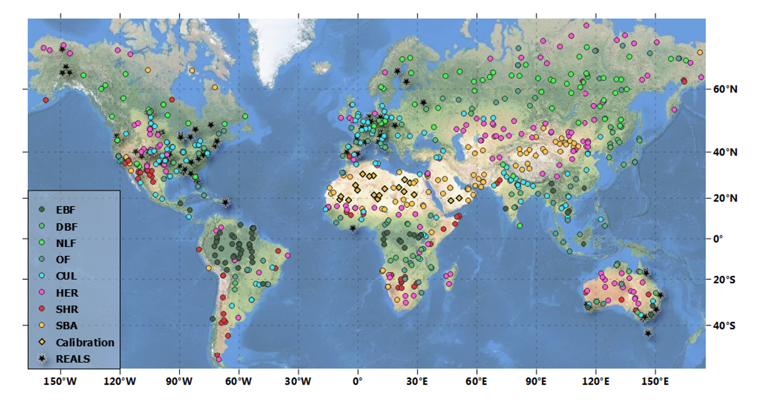
Figure. Global distribution of 99 REALS and 720 LANDVAL sites. LANDVAL are displayed per biome type: EBF stands for evergreen broadleaved forest, DBF for deciduous broadleaved forest, NLF for needle-leaf forests, OF for other forests, CUL for cultivated, HER for herbaceous, SHR for shrublands, and SBA for sparse and bare areas.
References:
- Fuster, B., Sánchez-Zapero, J., Camacho, F., García-Santos, V., Verger, A., Lacaze, R., Weiss, M., Baret, F., & Smets, B. (2020). Quality Assessment of PROBA-V LAI, fAPAR and fCOVER Collection 300 m Products of Copernicus Global Land Service. Remote Sensing, 12(6), 1017. https://doi.org/10.3390/rs12061017
- Lachérade, S., Fougnie, B., Henry, P., Gamet, P., Lacherade, S., Fougnie, B., Henry, P., & Gamet, P. (2013). Cross calibration over desert sites: Description, methodology, and operational implementation. IEEE Transactions on Geoscience and Remote Sensing, 51(3), 1098–1113. https://doi.org/10.1109/TGRS.2012.2227061
- Román, M. O., Schaaf, C. B., Lewis, P., Gao, F., Anderson, G. P., Privette, J. L., Strahler, A. H., Woodcock, C. E., & Barnsley, M. (2010). Assessing the coupling between surface albedo derived from MODIS and the fraction of diffuse skylight over spatially-characterized landscapes. Remote Sensing of Environment, 114(4), 738–760. https://doi.org/10.1016/j.rse.2009.11.014
- Román, M. O., Schaaf, C. B., Woodcock, C. E., Strahler, A. H., Yang, X., Braswell, R. H., Curtis, P. S., Davis, K. J., Dragoni, D., Goulden, M. L., Gu, L., Hollinger, D. Y., Kolb, T. E., Meyers, T. P., Munger, J. W., Privette, J. L., Richardson, A. D., Wilson, T. B., & Wofsy, S. C. (2009). The MODIS (Collection V005) BRDF/albedo product: Assessment of spatial representativeness over forested landscapes. Remote Sensing of Environment, 113(11), 2476–2498. https://doi.org/10.1016/j.rse.2009.07.009
- Sánchez-Zapero, J., Camacho, F., Martínez-Sánchez, E., Lacaze, R., Carrer, D., Pinault, F., Benhadj, I., & Muñoz-Sabater, J. (2020). Quality Assessment of PROBA-V Surface Albedo V1 for the Continuity of the Copernicus Climate Change Service. Remote Sensing 2020, Vol. 12, Page 2596, 12(16), 2596. https://doi.org/10.3390/rs12162596
- image
- Descarrega image
- link
