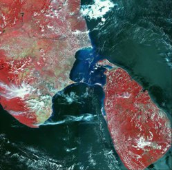
AwiFS
AWiFS
 |
The AWiFS (Advanced Wide Field Sensor) camera provides enhanced capabilities compared to the WiFS camera on-board IRS-1C/1D, in terms of spatial resolution (56 m Vs 188m), radiometric resolution (10 bits Vs 7 bits) and Spectral bands (4 Vs 2) with the additional feature of on-board detector calibration using LEDs. The spectral bands of AWiFS are same as LISS-III. The AWiFS camera is realized in two electro-optic modules viz.,. AWiFS-A and AWiFS-B, each containing four band assemblies. A combined swath of 740 Km is realized by mounting the two modules on the Deck, with their optical axes tilted by 11.94 deg away from the + yaw axis in opposite direction. With this mounting, a side lap of 128 pixels i.e., about 7.2kKm, is available in the combined swath. AGENCY: ISRO |
| Status: | Operational | |
|---|---|---|
| Satellite | IRS-P6 | |
| Launch Date: | October 2003 | |
| Type: | Two parallel radiometers, 4 VIS/NIR/SWIR channels | |
| Measurements and Applications: | Vegetation and crop monitoring, resource assessment (regional scale), forest mapping, land cover/ land use mapping, and change detection | |
Technical Characteristics | ||
| Resolution: | 55 m | |
| N. of Bands: | 4 | |
| Wavebands: | VIS: 0.52 - 0.68 µm, | |
| Swath: | 730 km | |
Resources | ||
Links | ||
| IRS-P6 Web page | http://www.nrsc.gov.in/satellites/irs-p6.html | |
