LPV DIRECT V2.1 DB
CEOS WGCV LPV DIRECT V2.1 database
Ground references of high quality are needed to validate satellite-based products. The DIRECT V2.1 database compiles Leaf Area Index (LAI), fraction of absorbed photosynthetically active radiation (FAPAR) and fraction of vegetation cover (FCover) averaged values over a 3 km x 3 km area. The ground data was upscaled using high spatial resolution imagery following CEOS WGCV LPV LAI good practices to properly account for the spatial heterogeneity of the site. Ground measurements including in the first version (DIRECT) were resulting from several international activities including VALERI, BigFoot, SAFARI-2000, CCRS, Boston University and ESA campaigns compiled by S. Garrigues (Garrigues et al., 2008), and later ingested in the CEOS WGCV LPV OLIVE tool (Weiss et al., 2014) for accuracy assessment. F. Camacho reviewed DIRECT to remove those sites without understory measurements (Camacho et al., 2013) and after that expanded the database with ImagineS sites (Camacho et al., 2021). DIRECT V2.1 is the last update including 44 new sites from China (Fang et al., 2019; Song et al., 2021) and 2 sites from ESA FRM4Veg (Brown et al., 2021).
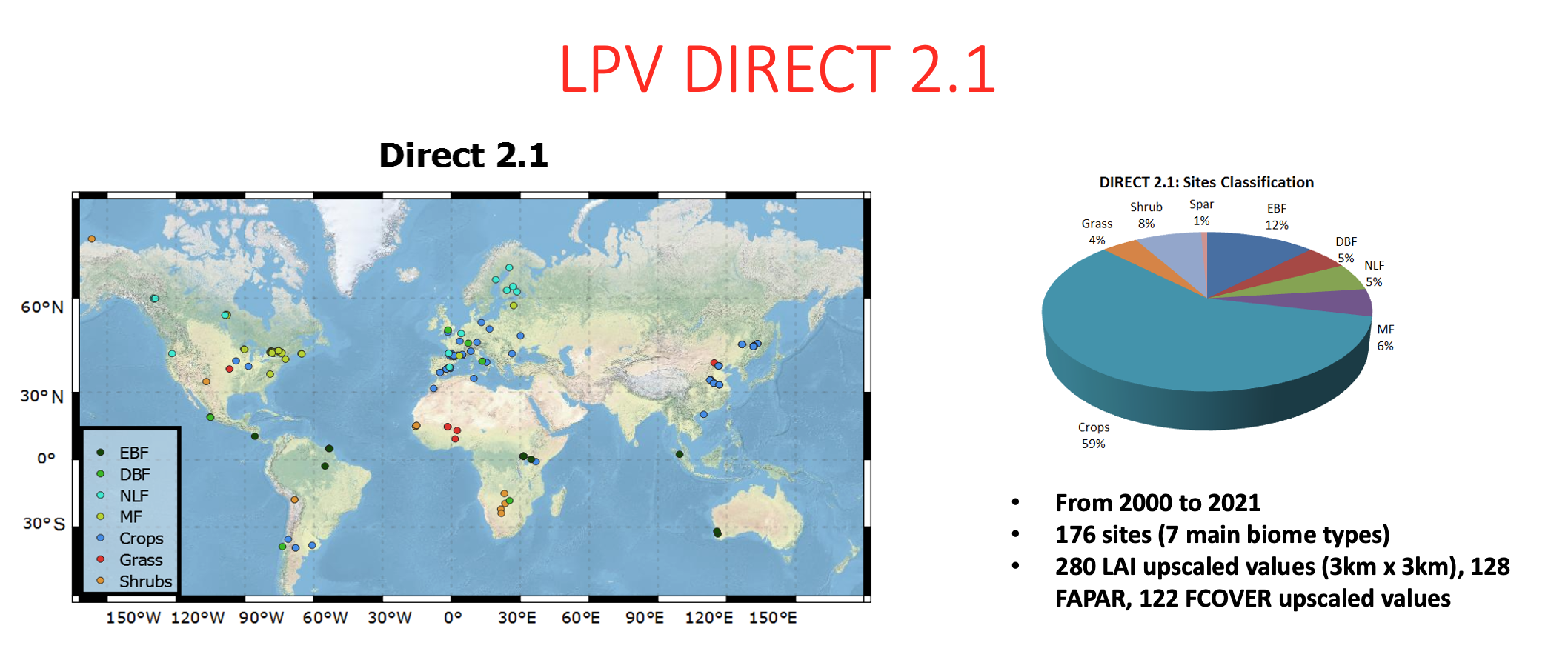
The CEOS WGCV LPV DIRECT V2.1 database constitutes a major effort of the international community to provide ground reference for the validation of LAI and FAPAR ECVs, with a total of 176 sites around the world (7 main biome types) and 280 LAI values, 128 FAPAR and 122 FCOVER values covering the period from 2000 to 2021.

Figure - Location of Direct v2.1 sites
Please download here the DIRECT V2.1 database
Contact:
Fernando Camacho fernando.camacho@eolab.es
Data description
- LAI, LAIeff, FAPAR and FCOVER upscaled values over 3 km x 3 km
- LAI_NoUnderstory, refers to sites where only overstory was measured and thus are not recommended for accuracy assessment of satellite products.
File contents
A Header " Sites":
General information for each site (coordinates, landcover, method, reference)
For each variable:
- # number of the site (site description in Sites)
- Lat_cen, latitude centre of 3km x 3km
- Lon_cen, longitude centre of 3km x 3km
- Site name, name of the site
- Date, MM/DD/YYYY
- Mean, average value over 3km x 3km
- Uncert, uncertainty over 3 km x 3km
References
Brown, L.A.; Camacho, F.; García-Santos, V.; et al (2021). Fiducial Reference Measurements for Vegetation Bio-Geophysical Variables: An End-to-End Uncertainty Evaluation Framework. Remote Sens, 13, 3194.
Camacho, F.; Cernicharo, J.; Lacaze, R.; Baret, F.; Weiss, M. (2013). GEOV1: LAI, FAPAR essential climate variables and FCOVER global time series capitalizing over existing products. Part 2: Validation and intercomparison with reference products. Remote Sens. Environ, 137, 310–329.
Camacho, F.; Fuster, B.; Li, W.; et al. (2021). Crop specific algorithms trained over ground measurements provide the best performance for GAI and fAPAR estimates from Landsat-8 observations. Remote Sens. Environ, 260, 112453.
Fang, H. et al., (2019). Validation of global moderate resolution leaf area index (LAI) products over croplands in northeastern China. Remote Sens. Environ., 233, 111377.
Garrigues, S.; Lacaze, R.; Baret, F.; Morisette, J.; Weiss, M.; Nickeson, J.; Fernandes, R.; Plummer, S.; Shabanov, N.V.; Myneni, R.; et al. (2008). Validation and intercomparison of global leaf area index products derived from remote sensing data. J. Geophys. Res. 2008, 113, G02028.
Song, B.; Liu, L.; Du, S. et al. (2021). ValLAI_Crop, a validation dataset for coarse-resolution satellite LAI products over Chinese cropland. Scientific Data 8, 243.
Weiss et al., (2014). On Line Validation Exercise (OLIVE): A Web Based Service for the Validation of Medium Resolution Land Products. Application to FAPAR Products. Remote Sens, 6, 4190-4216
