
SALVAL
- headline
- text
-
SALVAL HOME
Using the Tool
Sampling
Contact & Acknowledge
The overall aim of SALVAL is to bring together validation good practices protocols, ground data and satellite products to provide users with traceable (i.e. reproducible) validation results allowing reaching CEOS WGCV LPV validation Stage 4.
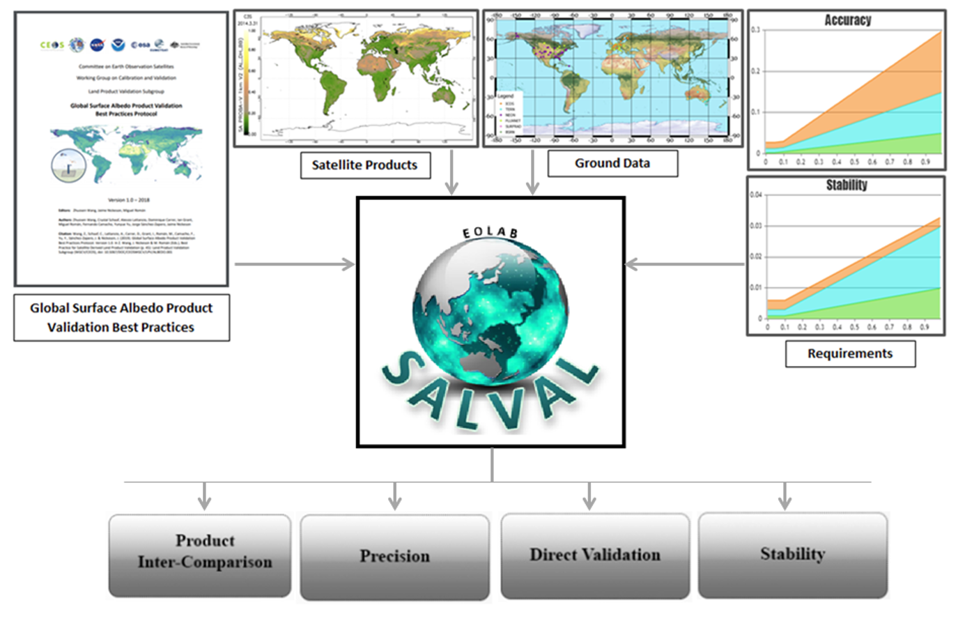
The SALVAL (Surface Albedo VALidation) tool provides the user with:
- A user-friendly interface for comparison of new satellite-based land surface albedo data products against ground reference data and existing validated land surface albedo products.
- A traceable, transparent, and consistent methodology following the CEOS WGCV LPV Surface Albedo validation good practices protocol for conducting the validation exercise.
- A flexible tool that allows for setting up the exercise with user defined requirements, albedo quantities, extents, or periods of interest to analyse results either interactively (via graphs and maps) or creating a standardized validation report in pdf format.
- A tool to benchmark new products, update product validation results or add new ground reference data.
SALVAL has the following components:
- Protocols and validation methodology from community-agreed protocols and standards defined by the Land Product Validation (LPV) subgroup of the Working Group on Calibration and Validation (WGCV) of the Committee on Earth Observation Satellites (CEOS) (Wang et al., 2019) and by the Quality Assurance framework for Earth Observation (QA4EO). Methods are based on two main approaches: direct validation of satellite products with in-situ measurements and satellite products inter-comparison over a global sampling of sites. See sampling database description.
- A Surface Albedo satellite products database (NASA, COPERNICUS/EU C3S, ESA GlobAlbedo, China GLASS) and the possibility to import a new dataset.
- A unique high quality-controlled sub-set of in-situ measurements selected from 99 tower-based stations which match CEOS LPV standards for validation (spatial representativeness).
- The possibility to specify user requirements for evaluating the fit-for-purpose of the evaluated products in terms of stability or accuracy over global or continental areas.
The tool allows evaluating different criteria, such as product continuity, temporal and spatial consistency, statistical agreement with other similar products, precision, stability and accuracy by comparison with independent measures in situ, among others (see a summary in the table below).
Category Sub-category Results Product inter- comparison Completeness Gap size distribution (spatial and temporal) and gap length. Spatial consistency Residual and difference maps, percentage of cases within requirements Temporal consistency Temporal profiles and histograms of cross-correlation Overall analysis Product histograms, difference Histograms, scatter-plots (APU validation metrics) and box-plots of bias and RMSD per bin Direct validation Temporal consistency Temporal profiles of the satellite-derived products vs ground data Overall analysis Scatter-plots (APU validation metrics) Precision Intra-annual precision Median 3-point difference (smoothness) Inter-annual precision Median absolute deviation over desert calibration sites Stability Slope of the linear regression per ten years over desert calibration sites Wang, Z., Schaaf, C., Lattanzio, A., Carrer, D., Grant, I., Roman, M., Camacho, F., Yang, Y., Sánchez-Zapero, J., 2019. Global Surface Albedo Product Validation Best Practices Protocol. Version 1.0. In Z. Wang, J. Nickeson & M. Román (Eds.), Best Practice for Satellite Derived Land Product Validation (p. 45): Land Product Validation Subgroup (WGCV/CEOS), doi: 10.5067/DOC/C [WWW Document]. https://doi.org/doi: 10.5067/DOC/CEOSWGCV/LPV/ALBEDO.001
- image
- تنزيل image
- link
