
Dataset description - OLIVE
Two independent datasets are used for the OLIVE validation exercise:
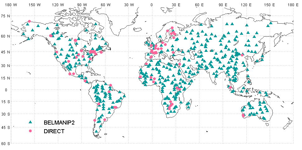
- BELMANIP2 (BEnchmark Land Multisite ANalysis and Intercomparison of Products) : It is an updated version of BELMANIP1 (Baret et al, 2006) which was built using sites from existing experimental networks (FLUXNET, AERONET, VALERI, BigFoot,...) completed with selected sites from the GLC2000 land cover map. To be independent from ground experiment measurments and better represent the variability of vegetation types and climatological conditions at the Earth surface, BELMANIP2 was built using the GLOBCOVER vegetation land cover map derived from MERIS images in 2009. The site selection was performed for each band of latitude (10° width) by keeping the same proportion of biome types within the selected sites as within the whole band of latitude. Attention was paid so that the sites were homogeneous over a 10x10km² area, almost flat, and with a minimum proportion of urban area and permanent water bodies. The original BELMANIP2 dataset included 420 sites. The updated one, BELMANIP2.1 dataset complements BELMANIP2 by adding 25 sites corresponding to bare soil areas (deserts) and tropical forests.
- DIRECT:it is a collection of sites for which ground measurements are available and that have been collected (Garrigues et al, 2008) and processed according to the CEOS-LPV guidelines. There is currently 113 data sets (sites and dates of measurements) available. However, this number is expected to grow by adding new sites to improve the accuracy assessment.
- BELMANIP2 and DIRECT site lists can be downloaded here (Excel file indicating site latitude and longitude for both datasets, name, web site and bibliographic references if they exist for the DIRECT sites).
- The ground validation values are provided here. Values of measured variable (Leaf Area index, FAPAR, FCOVER) are provided as an average value over the 3kmx3km area represented by the site.
- Google Earth files (kml) BELMANIP2 and DIRECT site can be downloaded here.
- DIRECT 2.0 ground database is now made available by LPV. DIRECT 2.0 filters forest sites with no understory and expands the time serie of up to 2017 with the inclusion of more than 60 new sites (coming from FP7 ImagineS, ESA and EOLAB campaigns). DIRECT 2.0 contains 140 sites and 242 samples (2000-2017). Please download the database from the following link: DIRECT 2.0
References
Baret, F., Morissette, J., Fernandes, R., Champeaux, J.L., Myneni, R., Chen, J., Plummer, S., Weiss, M., Bacour, C., Garrigues, S. and Nickeson, J.E., 2006. Evaluation of the representativeness of networks of sites for the validation and inter-comparison of land biophysical products. proposition of the CEOS-BELMANIP. IEEE Trans. Geosc. Remote Sens., 44(7): 1794-1803
Garrigues, S., Lacaze, R., Baret, F., Morisette, J.T., Weiss, M., Nickeson, J.E., Fernandes, R., Plummer, S., Shabanov, N.V., Myneni, R.B., Knyazikhin, Y. and Yang, W., 2008. Validation and intercomparison of global Leaf Area Index products derived from remote sensing data. J. Geophys. Res., 113, G02028: doi:10.1029/2007JG000635