Summary minutes/actions from the CEOS IVOS 24th Meeting,
May 8 – 10, 2012
U. S. Geological Survey (USGS)
Earth Resources Observation and Science (EROS) Center
IVOS Chair: Dr. Nigel Fox (NPL/BNSC)
Session support: Gyanesh Chander (SGT/USGS) and Philippe Goryl (ESA/ESRIN)
Executive Summary:
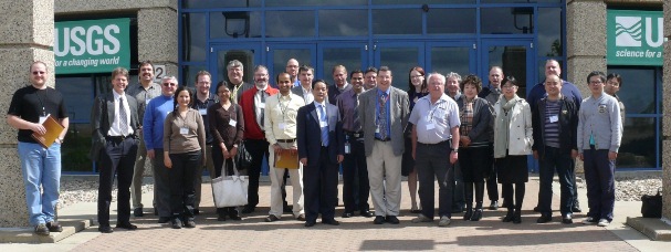
The Committee on Earth Observation Satellites (CEOS) Working Group on Calibration and Validation (WGCV) subgroup on Infrared and Visible Optical Systems (IVOS) meeting was held in Sioux Falls, SD from May 8 –10, 2012. The meeting was hosted under the auspices of the U. S. Geological Survey (USGS) Earth Resources Observation and Science (EROS) Center in partnership with the South Dakota State University (SDSU). There were around 30 participants from eight countries for the three day meeting. The IVOS sub-group mission is to ensure high quality calibration and validation of infrared and visible optical data from Earth Observation (EO) satellites and validation of higher level products. The objective of this meeting were to discuss the IVOS work plan, review sub-group missions and terms, finalize CEOS reference standard test sites, review actions and progress on key comparisons, discuss pre-flight calibration strategies, develop recommendations to the CEOS WGCV, discuss the QA4EO and ensure that the processes being established are "fit for purpose" for all stakeholders in all countries and agencies. The agenda also included discussion on existing and potential contributions from CEOS Working Group on Climate (WGC) and Land Surface Imaging (LSI) constellation to the CEOS IVOS.
Dr. Frank Kelly, USGS EROS Director, welcomed the participants and expressed strong USGS support to the IVOS group. A brief introduction to the USGS EROS Center was presented and it was brought to the group's attention that after a silent winter, the USGS turned on the Landsat 5 Thematic Mapper (TM) in late April to determine the state of the electronics problem that suspended operations in November, 2011. Unfortunately, several alternate methods of acquisitions did not alleviate the problem, which severely limits any further acquisitions with the TM. Currently, the USGS plans to acquire only a handful of images over the next few weeks as we examine our options. Landsat 5 has a long and storied career, and the data collected are invaluable to the study of our Earth. The Multi-Spectral Scanner (MSS) instrument on Landsat 5 has been reactivated and MSS data are being collected over the United States. The MSS data are being archived but processing and distribution of the data will not be possible until the USGS develops the necessary product generation capabilities. The session on the Land Surface Reflectance (test-sites) was very productive with a number of excellent presentations and discussion. Some of the key topics presented during this session were the 1) Results of sensor comparison using Tuz Golu test site (2010) 2) Lessons learned from post-Tuz Golu cross-comparison 3) Conclusions from Tuz Golu campaign – surface 4) Mirror based reflectors for radiometric calibration 5) Dome-C surface BRF measurements (2011/12) 6) Modeling of test-sites to reduce variability 7) Absolute Calibration of Optical Sensors Using Pseudo Invariant Calibration Sites 8) Experiences from the Arizona automated site 9) Pléiades over La Crau 10) Towards a comprehensive sensor performance test site. There was a lot of discussion leading to a recommendation on the instrumentation (and associated performance) needed for test-sites for establishing strategy for long-term maintenance of CEOS test-sites e.g. cost and benefit. Dr. Thome, provided an overview of the measurement needs for automated site characterization and summarized the various options for the core site instrumentation, sampling, budget, etc. A whitepaper on a set of recommendation will be developed and presented to the CEOS Plenary and SIT chair in the near future. The group thanked him for his efforts and helping the IVOS group to move forward with this action. The session of the Ocean Colour and Surface Temperature (Sea & Land) included presentation on the results from pilot comparison, activities needs of OCR-VC, GHRSST progress, virtual constellation on sea surface temperature, developing a long term international strategy (ISSI), and Cal/Val needs for a climate data set. The progress, highlights, and status from the RAdiation transfer Model Intercomparison (RAMI), atmospheric correction sensitivity analysis, Cal/Val Portal, GECA, LTDP, COVE, SADE, DIMITRI were also presented. Last year, IVOS formed two thematic focus group on: Geo/spatial Quality and Geometric Image quality. A Framework for Geo/Spatial Quality was presented with a goal to develop recommendations for procedures – test sites and analysis. Based on the success of previous IVOS workshops at ESA/ESRIN (2004) and JRC (2010), it was decided that the IVOS should seek to hold a technical community workshop on a focused topic on a tri-annual basis. The next workshop will be on pre-flight and on-board radiometric calibration of sensors probably in the spring of 2013. It was discussed that it should be a 3 to 4 days workshop, with 2 days on radiometric, 1 day on geometry and spatial and a day of wrap-up and conclusion. One of the goals of the workshop should be to capture the results and publish it for reference (similar to ASIC3). The near term goal is to define few sessions and form a technical committee and entertain vendors to participate. The session on the Sensor to Sensor Comparisons and Sensor Pre-/-in flight calibration included a progress report on the IVOS WG4 methods comparison, USGS/DMCii cross-calibration methods, Stability of VIIRS radiometric response, preliminary Calibration Results of Pléiades. There were also additional sessions that included discussion on the Quality Assurance Framework for Earth Observation (QA4EO) to ensure that the processes being established are "fit for purpose" for all stakeholders in all countries and agencies.