
Railroad Valley Playa - Cal/Val Wiki
Railroad Valley Playa (LANDNET SITE)
The dry lakebed of Railroad Valley Playa, Nevada is located at 1350 m above sea level (38.504° N latitude, 115.692° W longitude). It is a desert site with no vegetation with an overall size approximately 15 km by 15 km.

Typical atmospheric conditions at the site include an average aerosol optical depth at 550 nm of 0.060 [1]. The reflectance of the playa is generally greater than 0.3 and relatively flat spectrally except for the blue portion of the spectrum and an absorption feature in the shortwave infrared. Ground-based measurements of the directional reflectance characteristics of the playa show it to be nearly lambertian out to view angles of 30 degrees for incident solar zenith angles seen for overpasses of Terra and Landsat. [2]
 Temporal records for this site show reflectance variations as a function of time of year, with lowest reflectance in the winter months due to a rising water table. The accuracy of vicarious calibration experiments over land is highly dependent on the choice of an appropriate calibration target. Ideally, such a calibration site should be flat, bright, spatially uniform, spectrally stable over time, near lambertian for small angles off nadir, and of sufficiently large spatial extent. Desert playas are preferred for vicarious calibration of moderate spatial resolution sensors due to their optical properties, predictably sunny conditions and low atmospheric aerosol loading.
It is one of the CEOS LANDNET Sites. The site is managed by The University of Arizona (Remote Sensing Group) ; for more detailed information regarding the site, the point of contact is Kurt Thome (kthome@email.arizona.edu)
Instruments on the Test Site
TBD
_______________________________________________________________
Climatological Data for Railroad Valley Playa
| Parameter | Mean | Std Dev | Min | Max | Max-Min | (Max-Min)/Mean | CV |
|---|---|---|---|---|---|---|---|
| Cloud Fraction (%) | 0.3516 | 0.1862 | 0.1215 | 0.6505 | 0.5290 | 1.5044 | 0.5295 |
| Water Vapour Content (g/cm2) | 0.7856 | 0.4760 | 0.3030 | 1.7160 | 1.4130 | 1.7987 | 0.6060 |
| Precipitation (mm/day) | 0.6137 | 0.3891 | 0.2230 | 1.4190 | 1.1961 | 1.9489 | 0.6341 |
| Ozone Content (Dobson) | 313.9000 | 24.5506 | 284.5000 | 368.3000 | 83.8000 | 0.2670 | 0.0782 |
_________
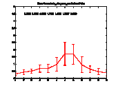
| Temporal Variability of Cloud Fraction: on the X axis scale is one year (Jan-Dec); on the Y axis scale is the fraction 0-1 |
 |
|
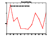
| Temporal Variability of Water Vapour Content: X axis scale is one year (Jan-Dec); Y axis scale is 0-6 g/cm2 |
 |
|
| Temporal Variability of Precipitation. X axis scale is one year (Jan-Dec); Y axis scale is 0-10 mm/day |
 |
|
| Temporal Variability of Ozone Content. X axis is one year (Jan-Dec); Y axis is 0-500 Dobson |
 |
|
| Spectral Temporal Variability | ||
Literature
[1] Thome, K, C. Cattrall, J. D’Amico, and J. Geis, 2005a, "Ground-reference calibration results for Landsat-7 ETM+", Proc. SPIE Conf. #5882.
[2] K. Thome, J. McCorkel, J. Czapla-Myers INFLIGHT INTERSENSOR RADIOMETRIC CALIBRATION USING THE REFLECTANCE-BASED METHOD FOR LANDSAT-TYPE SENSORS, Pecora 17 – The Future of Land Imaging…Going OperationalNovember 18 – 20, 2008, Denver, Colorado - PDF
[3] Mathias Kneubühler, Michael Schaepman, Kurt Thome, Fréderic Baret, Andreas Mülle, CALIBRATION AND VALIDATION OF ENVISAT MERIS PART 1: VICARIOUS CALIBRATION AT RAIL ROAD VALLEY PLAYA (NV) - PDF
[4] QA4E0 - Railroad Valley Questionnarie - PDF
[5] Mathias Kneubühler, Michael E. Schaepman, Kurtis J. Thome MERIS / ENVISAT FIRST YEAR VICARIOUS CALIBRATION RESULTS FROM RAILROAD VALLEY PLAYA (NV) - PDF
[6] Mathias Kneubühlera, Michael Schaepmanb and Kurt Thomec , LONG - TERM VICARIOUS CALIBRATION EFFORTS OF MERIS AT RAILROAD VALLEY PLAYA (NV) - AN UPDATE, 4th EARSeL Workshop on Imaging Spectroscopy, Warsaw, April 27-29 2005 - PDF
[7] K. Thome, J. Czapla-Myers, S. Biggar, Railroad Valley Playa for use in vicarious calibration of large footprint sensors - PRESENTATION - PDF
[8] Carol J. Bruegge, Mark Helmlinger, Wedad Abdou, Mark Helmlinger, and Barbara J. Gaitley RAILROAD VALLEY VICARIOUS CALIBRATION EXPERIMENT - PDF
Links
University of Arizona - College of Optical Science - Remote Sensing Group
USGS - Railroad Valley Playa Web Page
_________________________
View LANDNET SITES in a larger map