
Lake Tuz-Golu - Cal/Val Wiki
Lake Tuz-Golu (LANDNET SITE)
Lake Tuz (Turkish: Tuz Gölü meaning Salt Lake) is the second biggest lake in Turkey, 
It is the second largest lake in Turkey but its surface and water level vary according to the seasons. It reaches its higher level, 1-2 m/3-6 inches at the end of winter, and in summer after evaporation the lake dries out and a wide marsh covered with a 30cm/12 inches salt layer forms. Due to its high salinity (33%), 300 thousand tons of salt are obtained per year.
The evaporates are mainly halite and gypsum, with minor amounts of polyhalite and coelestine. No vegetation in the salt flat. But arable fields and salt-steppes surround the lake. Salt mines and saltwork pools operating in the lake.
As a natural reserve area, the site is well protected. There is virtually no vegetation in the salt flat but arable fields and salt-steppes surround it. There are salt mines and salt work pools operating at the margins of the lake.
Lake Tuz Golu, located at 38.83 N, 33.33 E, is a Salt Lake used for Absolute Radiometric Calibration
It is one of the CEOS LANDNET Sites. The site is managed by TUBITAK UZAY ; for more detailed information regarding the site, the point of contact is Hilal Ozen (hilal.ozen@uzay.tubitak.gov.tr)
Instruments on the Test Site
The site is instrumented with an automatic weather station, GPS, DGPS, ASD FieldSpec3 spectrometer and an automatic sunphotometer. All the meteorological instrumentation is available to all research groups taking part in ground campaigns
The Test Site is equipped with:
- Automatic Weather Station (Stable structure)
- ASD FieldSpec3 Spectroradiometer (Provided by NPL)
- Gonio Radiometer Spectrometer System (GRASS) - (provided by NPL)
- Microtops II Sunphotometer
- GPS
- Crescent DGPS
_____________________________________________________________________________
Climatological Data for Tuz Golu[1]
| Parameter | Mean | Std Dev | Min | Max | Max-Min | (Max-Min)/Mean | CV |
|---|---|---|---|---|---|---|---|
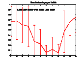
| Cloud Fraction (%) | 0.4265 | 0.2674 | 0.0475 | 0.7665 | 0.7090 | 1.6623 | 0.6269 |
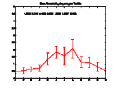
| Water Vapour Content (g/cm2) | 1.05852 | 0.5416 | 0.4850 | 2.0730 | 1.5880 | 1.5007 | 0.5118 |
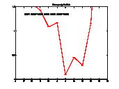
| Precipitation (mm/day) | 1.4171 | 0.9679 | 0.0940 | 3.4676 | 3.3736 | 2.3806 | 0.6830 |
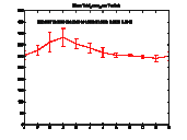
| Ozone Content (Dobson) | 322.8667 | 29.3840 | 290.2000 | 381.5000 | 91.3000 | 0.2828 | 0.0910 |
________________
| Temporal Variability of Cloud Fraction: on the X axis scale is one year (Jan-Dec); on the Y axis scale is the fraction 0-1 |
 |
|
| Temporal Variability of Water Vapour Content: X axis scale is one year (Jan-Dec); Y axis scale is 0-6 g/cm2 |
 |
|
| Temporal Variability of Precipitation. X axis scale is one year (Jan-Dec); Y axis scale is 0-10 mm/day |
 |
|
| Temporal Variability of Ozone Content. X axis is one year (Jan-Dec); Y axis is 0-500 Dobson |
 |
|
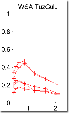
| Spectral Temporal Variability |
 |
|
Literature
[1] Lake Tuz-Gölü Tubitak Uzay Brochure - PDF
[2] Tuz Gölü Radiometric Calibration Test Site - QA4EO Workshop, Sep. 09 - PDF
[3] S. Gurol et al., TUZ GÖLÜ: NEW ABSOLUTE RADIOMETRIC CALIBRATION TEST SITE, ISPRS Congress, Benjing 2008. PDF
[4] QA4EO Questionnaire on Tuz Golu Lake - PDF
Links
_________________________
References
[1] WP230 - Site Characterization from Climatological Dataset