
Dunhuang - Cal/Val Wiki
Dunhuang (LANDNET SITE)
This site was operational radiometric calibration and validation for Chinese satellite sensors in 2001, and located on the east edge of the Kumutage Penniform Desert in Gansu province, South-West China.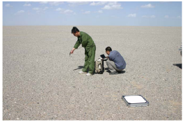
the city of Dunhuang . The whole target area for vicarious calibration is situated on a stabilised alluvial fan, 30 km x 30 km size. The area used for high spatial sensors (such as CBERS, TM etal) vicarious calibration measurements is approximately 400 m x 400 m in the centre of the fan and the surface comprises cemented gravels, and 15km×15km for low spatial sensors (Such as NOAA/AVHRR, FY-1/FY-3 optical imagers and EOS/MODIS etal )vicarious calibration with no vegetation. Sources of meteorological data for the site include the Dunhuang-PAM automated weather station, 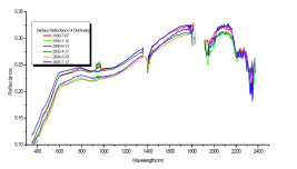
It is one of the CEOS LANDNET Sites. The site is managed by NSMC/CMA; for more detailed information regarding the site, the point of contact is Xiuqing Hu (huxq@cma.gov.cn)
Instruments on the Test Site
- ASD field spectroradimeter (350-2500nm)
- Sunphotometer (CE318)
- Weather observation (Dunhuang weather station)
- Ground surface and Soil Temperature
_____________________________________________________________________________
Climatological Data for Dunhuang
| Parameter | Mean | Std Dev | Min | Max | Max-Min | (Max-Min)/Mean | CV |
|---|---|---|---|---|---|---|---|
| Cloud Fraction (%) | 0.4080 | 0.1247 | 0.1830 | 0.5964 | 0.4134 | 1.0132 | 0.3055 |
| Water Vapour Content (g/cm2) | 0.8692 | 0.6696 | 0.2490 | 2.1530 | 1.9040 | 2.1906 | 0.7704 |
| Precipitation (mm/day) | 0.1836 | 0.1988 | 0.0075 | 0.6511 | 0.6436 | 3.5059 | 1.0827 |
| Ozone Content (Dobson) | 316.7750 | 24.2629 | 289.0000 | 349.1000 | 60.1000 | 0.1897 | 0.0766 |
________________
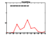
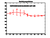
| Temporal Variability of Cloud Fraction: on the X axis scale is one year (Jan-Dec); on the Y axis scale is the fraction 0-1 |
 |
|
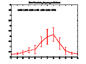
| Temporal Variability of Water Vapour Content: X axis scale is one year (Jan-Dec); Y axis scale is 0-6 g/cm2 |
 |
|
| Temporal Variability of Precipitation. X axis scale is one year (Jan-Dec); Y axis scale is 0-10 mm/day |
 |
|
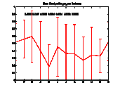
| Temporal Variability of Ozone Content. X axis is one year (Jan-Dec); Y axis is 0-500 Dobson |
 |
|
| Spectral Temporal Variability | ||
Literature
Links
_________________________
View LANDNET SITES in a larger map
References
[2] WP230 - Site Characterization from Climatological Dataset
[3] QA4EO Document - QA4EO-WGCV-IVO-CSP-002 - PDF